|
|
|
|
| DIRECTIONS TO THE PIER |
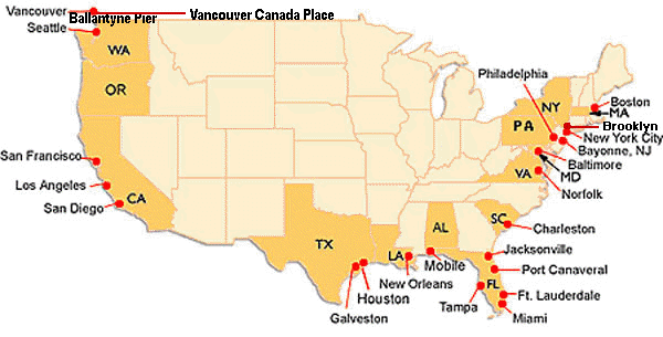
| To obtain driving directions to your US port of departure, click the appropriate port city in the list or on the map below. |
|
|
|
Port of Baltimore, Maryland: � From Interstate 95 North or South (I-95) take Exit 56 (Keith Avenue) � Turn left on Keith Avenue � Continue on Keith Avenue until it merges into Broening Highway � Take Broening Highway one mile to the Dundalk Marine Terminal � Make a right into the Visitor's Entrance (the first entrance into the terminal) � The guard at the entrance will provide further directions Return to Map |
|
|
|
Cape Liberty Cruise Port, Bayonne, New Jersey (New York Harbor) Cape Liberty Cruise Port 14 Port Terminal Boulevard Bayonne, NJ 07002-5038 General Directions: The terminal is just off Route 440 in Bayonne located on the Peninsula at Bayonne. The entrance to the peninsula is 1 1/2 miles south of Exit 14A of the New Jersey Turnpike or 1 1/2 miles north of the Bayonne Bridge. Directions to Pier: From Newark International Airport: � Exit the airport, following signs to the New Jersey Turnpike � Take the New Jersey Turnpike to exit 14A � Pay toll at exit and continue straight (after traffic light onto bridge) onto Route 440 � Follow signs for Route 440 South � Continue on Route 440 South to Port Terminal Blvd � Turn left at Port Terminal Blvd. (there is a traffic light at the intersection) � This is the entrance for the "Peninsula at Bayonne Harbor" or the old "Military Ocean Terminal Bayonne" � Continue straight and approach the guard gate � Continue past the guard gate and follow the signs to the cruise terminal From New Jersey Turnpike North or South: Take the New Jersey Turnpike to exit 14A. � Pay toll at exit and continue straight (after traffic light onto bridge) onto Route 440. � Follow signs for Route 440 South. � Continue on Route 440 South to Port Terminal Blvd. � Turn left at Port Terminal Blvd. (there is a traffic light at the intersection). � This is the entrance for the "Peninsula at Bayonne Harbor" or the old "Military Ocean Terminal Bayonne" � Continue straight and approach the guard gate. � Continue past the guard gate and follow the signs to the cruise terminal. From Staten Island or Bayonne Bridge: Take Route 440 North to the Bayonne Bridge. � Continue on Route 440 North to Port Terminal Blvd. � Turn right at Port Terminal Blvd. (there is a traffic light at the intersection). � This is the entrance for the "Peninsula at Bayonne Harbor" or the old "Military Ocean Terminal Bayonne" � Continue straight and approach the guard gate. � Continue past the guard gate and follow the signs to the cruise terminal. From Northern New Jersey: � Take the New Jersey Turnpike South to Exit 14A (Bayonne) � Follow New Jersey Turnpike Directions From Connecticut (near I-95): � Take I-95 south into New York State � Continue on I-95 to and over the George Washington Bridge � Follow signs for New Jersey Turnpike South � Follow New Jersey Turnpike Directions From Connecticut (near I-84): � Take I-84 West into New York State � Take I-684 South to I-287 West to I-87 South � Follow signs to and over the George Washington Bridge � Follow signs for New Jersey Turnpike South � Follow New Jersey Turnpike Directions From Westchester County: � Take I-684 South to I-287 West to I-87 South � Follow signs to and over the George Washington Bridge � Follow signs for New Jersey Turnpike South � Follow New Jersey Turnpike Directions From Rockland County: � Take the Palisades Parkway South to I-80 West � Follow signs for New Jersey Turnpike South � Follow New Jersey Turnpike Directions From The Bronx: � Proceed to and across the George Washington Bridge � Follow signs for New Jersey Turnpike South � Follow New Jersey Turnpike Direction From Manhattan: � Proceed to and through the Lincoln Tunnel � Follow I-495 West to the New Jersey Turnpike � Proceed South on the New Jersey Turnpike � Follow New Jersey Turnpike Directions From Brooklyn or Queens: � Enter Manhattan using the closest bridge or tunnel � Proceed across town to and through the Lincoln Tunnel � Follow I-495 West to the New Jersey Turnpike � Proceed South on the New Jersey Turnpike � Follow New Jersey Turnpike Directions From Southern New Jersey (near New Jersey Turnpike): � Take New Jersey Turnpike North � Follow New Jersey Turnpike Directions From Southern New Jersey (Shore Points): � Take the Garden State Parkway North to Exit 129 (New Jersey Turnpike) � Follow New Jersey Turnpike directions Return to Map |
|
|
|
Port of Boston, Massachusetts: Black Falcon Terminal Port of Boston Black Falcon Way S. Boston, MA 02210 Directions to Pier: From North (Traveling south on I-93) � On the expressway downtown, take exit marked "South Station" � At top of the exit ramp, turn left onto Summer Street � Continue on Summer Street as it merges with Congress Street � Continue on Congress Street to "D" Street and turn right onto "D" then left at the next light onto Summer Street again � At the next light on Summer Street is a left turn into the Boston Marine Industrial Park � The Black Falcon Terminal is the first right turn (onto Design Center Place) From South (Traveling on I-95 north, I-93 north, or the Southeast Expressway): � Pass through the South Station tunnel underneath downtown Boston/Chinatown � In the tunnel's right lane will be an off-ramp for Atlantic Avenue/Northern Avenue � Take this ramp, staying to the right and at the top of the ramp travel through the light onto the new Northern Avenue bridge � Follow Northern Avenue into the Boston Marine Industrial Park � At the end of Northern Avenue, turn right on Tide Street and then immediately right again onto Drydock Avenue � Take the next left onto Design Center Place to the Black Falcon Terminal From the Massachusetts Turnpike East: � Follow the Mass Turnpike East (I-90) to the end � When you see signs indicating "Turnpike Ends", stay to your right and exit at the off-ramp marked "Atlantic Avenue" � Stay right and follow signs for Atlantic Avenue � Continue on Atlantic Avenue until you reach the James Hook Lobster Company. Just before James Hook is the new Northern Avenue bridge on the right � Follow Northern Avenue into the Boston Marine Industrial Park � At the end of Northern Avenue, turn right on Tide Street and then immediately right again onto Drydock Avenue � Take the next left onto Design Center Place to the Black Falcon Terminal Boston Airport Information: Logan International Airport (BOS) 1 mile to the pier; approximate driving time - 20 minutes Return to Map |
|
|
|
Port of Brooklyn, New York: Brooklyn Cruise Terminal in Red Hook Bowne St & Imlay St Brooklyn, NY 11231 Directions to Pier: From Manhattan Via the Battery Tunnel: � Take the Battery Tunnel (I-478-E) into Brooklyn � Continue onto the westbound Brooklyn-Queens Expressway (I-278-W) and immediately take the first exit on the right, Exit 26 - Hamilton Avenue onto the service road � Stay to the left and make a left U-turn at the intersection of Hamilton Avenue with Clinton Street/9th Street, then continue west along the westbound Hamilton Avenue service road � Continue on the service road to its end at Van Brunt Street � Turn left at Van Brunt Street � Travel 2 blocks and then turn right onto Bowne Street to enter the terminal From Manhattan v the Brooklyn or Manhattan Bridges, and from LaGuardia Airport (LGA): � Get onto the westbound Brooklyn-Queens Expressway (I-278-W) and take Exit 26 - Hamilton Avenue onto the service road � Stay to the left and make a left U-turn at the intersection of Hamilton Avenue with Clinton Street/9th Street, then continue west along the westbound Hamilton Avenue service road � Continue on the service road to its end at Van Brunt Street � Turn left at Van Brunt Street � Travel 2 blocks and then turn right onto Bowne Street to enter the terminal From John F. Kennedy International Airport (JFK): � Get onto the westbound Brooklyn-Queens Expressway (I-278-E) to Exit 26 - Hamilton Avenue � After exiting, continue along westbound Hamilton Avenue service road � Continue on the service road to its end at Van Brunt Street � Turn left at Van Brunt Street, travel 2 blocks and then turn right onto Bowne Street to enter the terminal To/From Airport: Driving times are extremely unpredictable in New York, therefore, we suggest that you allow extra time to arrive at the cruise ship terminal/airport on time. Return to Map |
|
|
|
Port of Charleston, South Carolina: Charleston Union Pier Terminal 196 Concord Street Charleston, SC Directions to Pier: � Exit airport on I-526 and connect to I-26 (Charleston) � Continue to East Bay Street-Morrison Drive Exit (219-B) � Turn left at bottom of exit ramp � Continue on to Morrison Drive � Morrison Drive will change name to East Bay Street - in route � East Bay Street will cross Calhoun Street (traffic light intersection) � Turn left onto Calhoun Street � Turn right onto Washington Street � Stay on Washington Street, which will connect into Concord Street Return to Map |
|
|
|
Port Everglades, Fort Lauderdale, Florida: Port Everglades SE 10th Avenue Fort Lauderdale, FL Directions to Pier: From I-95: � I-595 is an East/West Interstate with connections to I-95, the Florida Turnpike, US-1, State Road 7 (441), I-75 and the Sawgrass Expressway � Take I-595 East straight into Port Everglades � Once in Port Everglades, I-595 becomes Eller Drive/10th Avenue � At the traffic light, proceed straight on 10th Avenue � You will approach a sign with instructions that will direct you to the assigned terminal � The entrance to the Midport Parking Garage will be located on the left side of 10th Avenue North Entrance: � Take U.S.1 or A1A to 17th Street Causeway in Fort Lauderdale and turn south onto Eisenhower Boulevard US1/Federal Highway Entrance: � At the intersection of State Road 84 East and U.S.1 (Federal Highway), turn east into the seaport From Ft. Lauderdale International Airport: � Take the left lane (US 1 North as you depart from the airport). � Get into the right lane (I-595 East) to continue to Eller Drive Transit Time/Distance from Fort Lauderdale International Airport (FLL) to Port Everglades - 5 minutes / 2 miles Transit Time/Distance from Miami International Airport (MIA) to Port Everglades - 45 minutes / 30 miles Return to Map |
|
|
|
Port of Galveston, Texas: Texas Cruise Ship Terminal of Galveston Island 25th and Harborside Drive Galveston, TX Directions to Pier: From George Bush Intercontinental Airport in Houston: � Take I-45 south to Exit 1C � Turn left (east) onto Harborside Drive/Highway 275 � Continue 4.7 miles to Kempner/22nd Street (which is the street leading into the Cruise Ship Terminal entrance) and turn left � The area adjacent to the terminal is for loading and unloading luggage curbside only. Transit Time/Distance from George Bush Intercontinental Airport (IAH) to the Port of Galveston - 2 hours / 65 miles Return to Map |
|
|
|
Port of Houston, Texas: Bayport Cruise Terminal 4700 Cruise Road Pasadena, TX 77586 Directions to Pier: From George Bush Intercontinental Airport: � Take 45 South through downtown Houston to 610 � Take 610 North to 225 East (to Pasadena) � Take 225 East for 18 miles to 146 South � Take 146 South for 9 miles to Repsdorph � Turn East onto Repsdorph and continue East on Repsdorph � Take Meyer to Todville Road � Turn North on Todville Road and follow Todville Road to El Jardin Drive � Turn West � El Jardin Drive becomes Cruise Terminal Road � Take Cruise Terminal Road to Houston�s Bayport Cruise Terminal From From 45 South/Houston Hobby Airport: � Take 45 South to NASA Road 1 � Turn East on NASA Road 1 and drive 20 miles to 146 � Take 146 North (Left) � Follow 2 miles to Repsdorph � Turn East onto Repsdorph and continue East on Repsdorph � Take Meyer to Todville Road � Turn North on Todville Road and follow Todville Road to El Jardin Drive � Turn West � El Jardin Drive becomes Cruise Terminal Road � Take Cruise Terminal Road to Houston�s Bayport Cruise Terminal Return to Map |
|
|
|
Port of Jacksonville, Florida: JAXPORT Cruise Terminal 9810 August Drive Jacksonville, FL 32226 Directions to Pier: From North: � Take I-95 South to State Road 9-A South, exit 362-A, (1 mile past Jacksonville International Airport) � Take State Road 9-A South for 6 miles to Heckscher Drive Exit (State Road 105) � Turn right on Heckscher Drive (SR 105) � Cross New Berlin Road, and go about � mile � Turn left on August Drive into cruise terminal entrance � Follow signs to parking From South: � Take I-95 North, through Jacksonville, to Heckscher Drive, exit 358-A (State Road 105 North) � Stay on Heckscher Drive/SR 105 North; pass the Jacksonville Zoo, and travel about 4 miles � Turn right on August Drive into the cruise terminal entrance � Follow signs to parking From West: � Take I-10 East toward Jacksonville � Take I-295 North (this becomes State Road 9-A), exit 356 � Pass the interchange for I-95, staying on I-295/SR 9-A South for six miles to Heckscher Drive exit � Turn right on Heckscher Drive (State Road 105 South) � Cross over New Berlin Road and go about � mile � Turn left into cruise terminal entrance on August Drive � Follow signs to parking From Jacksonville International Airport: � Leave JIA via Airport Road, east toward I-95 � Take I-95 South for 1 mile to State Road 9-A South (Exit 362-A, one mile past Jacksonville International Airport) � Continue on State Road 9-A South 6 miles � Turn right on Heckscher Drive (State Road 105) � Cross over New Berlin Road and go about � mile � Turn left into cruise terminal entrance on August Drive � Follow signs to parking To/From Airport: Jacksonville International Airport (JIA) is approximately 15 minutes from the cruise terminal Return to Map |
|
|
|
Port of Los Angeles, California: Berths 91-93 World Cruise Center San Pedro, CA 90731 Directions to Pier: From Long Beach Area: � Take Ocean Boulevard West and then Vincent Thomas Bridge to the first off-ramp (San Pedro) � Continue across Harbor Boulevard to the pier From Downtown Los Angeles: � Travel southbound on the Harbor Freeway (Interstate 110) � Exit at Harbor Boulevard and proceed straight through the Harbor Boulevard intersection � Turn right to enter the World Cruise Center From Los Angeles International Airport: � Follow the signs to I-405 South (San Diego Freeway) � Exit to I-110 South (Harbor Freeway) to Harbor Boulevard exit � Continue across Harbor Boulevard to the pier To/From Airport: Los Angeles International Airport (LAX) - 60 minutes / 25 miles Return to Map |
|
|
|
Port of Miami, Florida: Africa Way and South America Way Dodge Island Miami, FL 33132 Directions to Pier: From Miami International Airport to the Port of Miami: � Take SR 836 East through the toll. Exit at N.E. 2nd Avenue/Biscayne Blvd (US 1) � Turn right on N.E. 2nd Avenue. Stay in the left lane to N.E. 5th Street � Turn left on N.E. 5th Street and drive across the big bridge � Follow the signs to the piers From Ft. Lauderdale International Airport or Broward County to the Port of Miami: � Drive I-95 South to Miami Beach I-395 (Exit #5). Exit at N.E. 2nd Avenue/Biscayne Blvd (US1) � Turn right on N.E. 2nd avenue and stay in your left lane to N.E. 5th Street � Turn left and drive across the big bridge � Follow the signs to the piers From South Dade Area to the Port of Miami: � Take SR 826 North to SR 836 East through the toll � Exit at N.E. 2nd Avenue/Biscayne Blvd (US 1) � Turn right on N.E. 2nd Avenue. Stay in the left lane to N.E. 5th Street � Turn left on N.E. 5th Street and drive across the big bridge � Follow the signs to the piers From Florida Keys to the Port of Miami: � Take US 1 North to Florida Turnpike North. Follow signs to 874 North to SR 836 East � Travel through the toll. Exit at N.E. 2nd Avenue/Biscayne Blvd (US 1) � Turn right on N.E. 2nd Avenue. Stay in the left lane to N.E. 5th Street � Turn left and drive across the big bridge � Follow the signs to the piers From Orlando to the Port of Miami: � Take Florida Turnpike to I-95 South � Drive I-95 South to Miami Beach I-395 (Exit #5). Exit at N.E. 2nd Avenue/Biscayne Boulevard (US1) � Turn right on N.E. 2nd Avenue to N.E. 5th Street � Turn left on N.E. 5th Street and drive across the big bridge � Follow the signs to the piers From Downtown Miami to Miami International Airport: � Take Biscayne Boulevard North to I-195 West (36th Street) � Continue West on S.R. 112 to airport To/From Airports: Miami International Airport (MIA) - approximately 20 miles west of the Port of Miami Ft. Lauderdale International Airport (FLL) - approximately 45 minutes north of the Port of Miami West Palm Beach International (PBI) - approximately 90 minutes north of the Port of Miami Return to Map |
|
|
|
Port of Mobile, Alabama: 250 North Water Street Alabama State Docks Intersection of Beauregard Road and Water Street Mobile, AL 36602 Directions to Pier: From I-65 North or South: � Take I-65 to I-165 � Exit at Water Street � Follow signs to ship terminal � Security check-in will take place at the Hank Aaron Loop � All guests will be pre-screened before proceeding to the parking lot and cruise terminal From I-10 East or West: � Exit at Water Street � Follow signs to ship terminal � Security check-in will take place at the Hank Aaron Loop � All guests will be pre-screened before proceeding to the parking lot and cruise terminal To/From Airport: Mobile Regional Airport (MRA) - 30 minutes / 13.5 mile Return to Map |
|
|
|
Port of New Orleans, Louisiana: 980 Port of New Orleans Place New Orleans, LA 70130 Directions to Julia Street Cruise Ship Terminal: � Take I-10 East toward New Orleans � Follow signs for Westbank (Business 90) as you approach downtown � Exit at Tchoupitoulas Street/South Peters Street exit � Continue to Convention Center Boulevard � Right on Convention Center Boulevard � Continue to Henderson Street � Left on Henderson Street � Continue to Port of New Orleans Place � Left on Port of New Orleans Place to cruise terminals To/From Airport: New Orleans International Airport (MSY) - 30 minutes / 15 mile Return to Map |
|
|
|
Port of New York, New York: New York City Passenger Ship Terminal 711 12th Avenue at 55th Street New York City, New York 10019 Directions to Pier: From John F. Kennedy International Airport (JFK): � Exit the airport, following signs to Van Wyck Expressway � Take Van Wyck Expressway to Grand Central Parkway West/Triboro Bridge � While going over the bridge stay in the right lane, following signs to Manhattan Toll � Take the FDR South and exit at East 63rd Street. At the light (York Avenue) make a right onto East 55th Street � Take East 55th Street to 12th Avenue (West Street) and proceed through the gate marked Passenger Ship Terminal � Follow the signs to the appropriate berth From LaGuardia International Airport (LGA): � Exit the airport, following signs to Grand Central Parkway West/Triboro Bridge � While going over the bridge stay in the right lane, following signs to Manhattan Toll � Take the FDR south and exit at East 63rd Street � At the light (York Avenue) make a right onto East 55th Street � Take East 55th Street to 12th Avenue (West Street) and proceed through the gate marked Passenger Ship Terminal � Follow the signs to the appropriate berth From Newark (New Jersey) International Airport (EWR): � Exit the airport, following signs to the New Jersey Turnpike. At the toll plaza, follow signs to the New Jersey Turnpike North. � Take the New Jersey Turnpike North to Exit 16E (Lincoln Tunnel) � When you exit the tunnel, follow the signs to 10th Avenue/Uptown � Take 10th Avenue to West 55th Street and make a left onto West 55th Street � Take 12th Avenue (West Street) and proceed through the gate marked Passenger Ship Terminal � Follow the signs to the appropriate berth From Midtown Manhattan: � Proceed to West 55th Street and take 12th Avenue (West Street) � Proceed through the gate marked Passenger Ship Terminal � Follow the signs to the appropriate berth To/From Airports: Driving times are extremely unpredictable in New York, therefore, we suggest that you allow extra time to arrive at the cruise ship terminal/airport on time. Return to Map |
|
|
|
Port of Norfolk, Virginia: Nauticus National Maritime Center One Waterside Drive Norfolk, VA 23510 Directions to Pier: From Richmond (West) to Harbor Park Parking Site: � Take I-64 East towards Williamsburg/Norfolk, VA � Proceed through the Hampton Roads Bridge Tunnel into Norfolk � Turn right onto I-264 West to Downtown Norfolk � Exit at Waterside Drive (Exit 9) � At the end of the exit ramp, make a left onto Water Street � Follow Water Street to Harbor Park From Richmond (West) to Cedar Grove Parking Site: � Take I-64 East towards Williamsburg/Norfolk, VA � Proceed through the Hampton Roads Bridge Tunnel into Norfolk � Turn right onto I-264 West to Downtown Norfolk � Take City Hall Exit (Exit 10) � At the end of the ramp, make a right onto St. Paul's Boulevard � Continue straight until St. Paul's Blvd turns into Monticello Avenue � Cedar Grove Parking Site is located on the right off of Monticello Avenue From Washington, DC (North) to Harbor Park Parking Site: � Take I-95 South � Exit onto I-295 South to Williamsburg/Norfolk, VA (Exit 84) � Take I-64 East towards Williamsburg/Norfolk, VA (Exit 200) � Proceed through the Hampton Roads Bridge Tunnel into Norfolk � Turn right onto I-264 West to Downtown Norfolk � Exit at Waterside Drive (exit 9) � At the end of the exit ramp, make a left onto Water Street � Follow Water Street to Harbor Park From Washington, DC (North) to Cedar Grove Parking Site: � Take I-95 South � Exit onto I-295 South to Williamsburg/Norfolk, VA (Exit 84) � Take I-64 East towards Williamsburg/Norfolk, VA (Exit 200) � Proceed through the Hampton Roads Bridge Tunnel into Norfolk � Turn right onto I-264 West to Downtown Norfolk � Take City Hall Exit (Exit 10) � At the end of the ramp, make a right onto St. Paul's Boulevard � Continue straight until St. Paul's Blvd turns into Monticello Avenue � Cedar Grove Parking Site is located on the right off of Monticello Avenue From North Carolina (South) to Harbor Park Parking Site: � Take I-95 North to Emporia, VA � Exit onto US-58 East (Exit 11) towards Suffolk/Norfolk/Virginia Beach � In Suffolk, US-58 will merge with US-13; continue east � Follow US-58/US-13 onto I-264 West towards Downtown Norfolk � Proceed through the Downtown Tunnel into Norfolk � Take Waterside Drive Exit (Exit 9) � At the end of the ramp, make a left onto Water Street � Follow Water Street to Harbor Park Traveling from North Carolina (South) to Cedar Grove Parking Site: � Take I-95 North to Emporia, VA � Exit onto US-58 East (Exit 11) towards Suffolk/Norfolk/Virginia Beach � In Suffolk, US-58 will merge with US-13; continue east � Follow US-58/US-13 onto I-264 West towards Downtown Norfolk � Proceed through the Downtown Tunnel into Norfolk � Take Waterside Drive/St Paul's Boulevard Exit (Exit 9); follow St Paul's Boulevard signs � At the end of the ramp, make a right onto St Paul's Boulevard � Continue straight until St Paul's Boulevard turns into Monticello Avenue � Cedar Grove Parking Site is located on the right off of Monticello Avenue To/From Airports: Norfolk International Airport (ORF) - 20 minutes / 12 mile Newport News/Williamsburg International Airport (PHF) - 30 minutes Return to Map |
|
|
|
Port of Philadelphia, Pennsylvania: Philadelphia Naval Business Center (PNBC) Philadelphia Cruise Terminal 1 5100 South Broad Street Philadelphia, PA 19112 Directions to Pier: From Points North of Philadelphia: � Take I-95 South to Exit 17(Broad Street) � At the bottom of the ramp turn left at the second traffic light onto Broad Street � Enter the main gate of the Philadelphia Naval Business Center From Points South of Philadelphia: � Take I-95 North to Exit 17 (Broad Street) � The off-ramp merges onto Broad Street North � Stay to the left and turn left at the first traffic light onto Zinkoff Boulevard � At the next traffic light make a quick left onto Broad Street South � Stay to the right and enter the main gate of the Philadelphia Naval Business Center From Points East of Philadelphia: � From New Jersey traveling across the Benjamin Franklin Bridge (BFB) or Walt Whitman Bridge (WWB) � At the end of the bridge follow signs for I-95 South to Exit 17(Broad Street) � At the bottom of the ramp turn left at the second traffic light onto Broad Street � Enter the main gate of the Philadelphia Naval Business Center From Points West of Philadelphia: � Take I-76 East to Exit 349 (Broad Street) � Bear right at the end of the off-ramp onto Broad Street South � Travel 1.0 mile to the main gate of the Philadelphia Naval Business Center From the Pennsylvania Turnpike: � Take Exit 326 (Valley Forge) � Travel East on I-76. Exit at 349 (Broad Street) � Bear right at the end of the off-ramp onto Broad Street South � Travel 1.0 mile to the main gate of the Philadelphia Naval Business Center From I-476: � Take I-476 South to I-95 North. to Exit 17 (Broad Street) � The off-ramp merges onto Broad Street North � Stay to the left and turn left at the first traffic light onto Zinkoff Blvd � At the next traffic light make a quick left onto Broad Street South � Stay to the right and enter the main gate of the Philadelphia Naval Business Center From Center City Philadelphia: � Take Broad Street South past the Stadiums and into the main gate of the Philadelphia Naval Business Center To/From Airport: Philadelphia International Airport (PHL) - 10 minutes / 7 mile Return to Map |
|
|
|
Port Canaveral, Cape Canaveral, Florida: Cruise Terminal #2 - 180 Christopher Columbus Drive Cruise Terminal #3 - 220 Christopher Columbus Drive Cruise Terminal #4 - 240 Christopher Columbus Drive Cruise Terminal #5 - 9245 Charles Rowland Drive Cruise Terminal #8 - 9155 Charles Rowland Drive Cruise Terminal #10 - 9005 Charles Rowland Drive The above addresses are in Cape Canaveral, FL 32920 Directions to Pier: From South: � Proceed north on I-95 to SR-528 (Beeline Expressway) to exit #77 � Take exit #77 and drive east approximately 12 miles � Cross the Banana River and watch for signs to Port Canaveral Cruise Terminals From North: � Proceed south on I-95 to SR-528 (Beeline Expressway) to exit #77 � Take exit #77 and drive east approximately 12 miles � Cross the Banana River and watch for signs to Port Canaveral Cruise Terminals From North: � Proceed east on SR-528 (Beeline Expressway), all the way to Port Canaveral � After you pass I-95, drive east for approximately 12 more miles � Cross the Banana River and watch for signs to Port Canaveral Cruise Terminals Signs along the highway will direct you to the cruise terminals at Port Canaveral. Cruise Terminals 5, 8, and 9/10 are located on the north side of the Port and can be reached via S.R. 401. Cruise Terminals 2, 3 and 4 are on the south side near the Port's oceanfront campground, Jetty Park. Turn left off S.R. 528 into Port Canaveral, and follow the signs. To/From Airports: Orlando International Airport (MCO) - 60 minutes / 45 mile Melbourne International Airport (MLB) - 45 minutes south/ 25 miles Return to Map |
|
|
|
Port of San Diego, California: San Diego "B" Street Cruise Ship Terminal 1140 North Harbor Drive San Diego, CA 92112 Directions to Pier: From North: � Take I-5 south � Take the exit for the San Diego International Airport � Continue straight on Kettner Boulevard � Turn right on Laurel Street � After crossing over Pacific Highway, stay in the left lane � Turn left on Harbor Drive and proceed to the terminal From South and Alternate Route From North: � I-5 north or south � Take the Front Street exit and head south on Front Street � Turn right on Broadway � Turn right on Harbor Drive and proceed to the terminal From San Diego International Airport: � Exit the Airport on Harbor Boulevard South towards downtown area which leads to the pier From Los Angles International Airport: � Exit the airport seeking Freeway 405 South � This will connect with I-5 South � Follow I-5 South directly into San Diego � Exit the Freeway at the Airport exit � This will lead you onto Kettner Boulevard � Follow Kettner Boulevard until Laurel Boulevard � Turn left onto Laurel Boulevard � Then turn left onto Harbor Boulevard, which leads to the pier � This is well marked by road signs To/From Airports: San Diego International Airport (SAN) - 15 minutes / 3 mile Los Angles International Airport (LAX) - 2.5 hours / 112 mile Return to Map |
|
|
|
Port of San Francisco, California: Pier 35 (at the end of Bay Street) The Embarcadero San Francisco, CA 94133 Directions to Pier: From South: � Take 280 North (or 101 to the 280/101 Interchange, about 1.5 miles north of Candlestick Park, then take 280 North) � Exit at the end of 280 Freeway at King � Continue 3 blocks on King, which turns into The Embarcadero traveling west � Proceed approximately 2 miles to Pier 35 � Turn right, into Pier 35 From the East Bay, Bay Bridge: � Take Fremont Exit (on right side of bridge) � Proceed 1 block to Mission � Turn right on Mission and proceed 4 blocks to The Embarcadero � Turn left on The Embarcadero � Proceed approximately 1.5 miles to Pier 35 � Turn right, into Pier 35 From North: � Take 101 South to San Francisco � Exit Lombard Street � Take Lombard East about 1.5 miles to Van Ness � Turn left on Van Ness and proceed 3 blocks to Bay Street � Turn right on Bay and proceed approximately 1 mile to The Embarcadero � Turn left on The Embarcadero � Pier 35 is immediately to the right of The Embarcadero To/From Airport: San Francisco International Airport (SFO) - 25 minutes / 15 mile Return to Map |
|
|
|
Port of Seattle, Washington: Bell Street Pier Cruise Terminal 2225 Alaskan Way Seattle, WA 98121 Directions to Pier: From I-5 South: � Take Exit 167, West Mercer Street/Fairview Avenue � Turn right onto Fairview Avenue � Take the first left onto Valley Street � Stay left, Valley Street merger into Broad Street � Continue on Broad Street to Alaskan Way � Pier 66 will be on the right From Sea-Tac International Airport: � Take I-5 north. Take the Madison exit (also called Convention Place exit) � Turn left onto Madison. Stay on Madison until you come to the waterfront � Turn right on Alaska Way � Pier 66 is on the left just past the skybridge To/From Airport: Seattle International Airport (SEA) - 30 minutes / 30 mile Return to Map |
|
|
|
Port of Tampa, Florida: 1101 Channelside Drive Tampa, FL 33602 The Seaport Street Terminal is located in an area referred to as the Garrison Seaport Center and is adjacent to the Florida Aquarium. Directions to Pier: From North: � I-75 South to I-4 West or I-275 South to I-4 East � Take Exit 1 (Port of Tampa/Ybor City) � Take 21st Street South � Turn right on East Adamo Drive/Highway 60 � East Adamo Drive/Highway 60 will turn into Channelside Drive/13th Street � Bear to the left and follow signs for the Florida Aquarium/Seaport Terminal � The long-term parking lot will be on the right hand side of the street From South: � I-75 North � Take Crosstown Expressway West (toward Tampa) � Take 22nd Street North Exit (Port of Tampa/Ybor City) � Take 22nd Street North � Turn left on East Adamo Drive/Highway 60 � East Adamo Drive/Highway 60 will turn into Channelside Drive/13th Street � Bear to the left and follow signs for the Florida Aquarium/Seaport Terminal � The long-term parking lot will be on the right hand side of the street From East: � I-4 West � Take Exit 1 (Port of Tampa/Ybor City) � Take 21st Street South � Turn right on East Adamo Drive/Highway 60 � East Adamo Drive/Highway 60 will turn into Channelside Drive/13th Street � Bear to the left and follow signs for the Florida Aquarium/Seaport Terminal � The long-term parking lot will be on the right hand side of the street From West/Tampa International Airport: � I-275 North (stay in right lane) � Take Exit 1 (Port of Tampa/Ybor City) � Take 21st Street South � Turn right on East Adamo Drive/Highway 60 � East Adamo Drive/Highway 60 will turn into Channelside Drive/13th Street � Bear to the left and follow signs for the Florida Aquarium/Seaport Terminal � The long-term parking lot will be on the right hand side of the street To/From Airport: Tampa International Airport (TPA) - 20 minutes / 15 mile Return to Map |
|
|
|
Port of Vancouver, Ballantyne Pier, Vancouver, British Columbia, (Canada): Ballantyne Pier North Foot of Heatley Street 851 Centennial Road Vancouver, BC V6C2P9 Directions to Pier: From Vancouver International Airport: � Travel east out of the airport on Grant McConachie Way � Follow the Highway 99 North signs which will take you over the Arthur Laing Bridge and onto Granville Street � Follow Granville Street north over the Granville Street Bridge, and take the Seymour Street exit � Proceed north to Hastings Street and turn right � Follow East to Clark Drive and turn left � Follow Clark Drive across the Clark Drive Overpass � At the bottom of the overpass, turn right at the stop sign onto Centennial Road � Follow centennial Road to Ballantyne Pier From Seattle-Tacoma International Airport: � Leaving Seattle-Tacoma International Airport, follow the signs marked Freeways after exiting airport arrival terminals � Enter Eastbound Highway 518 (also marked I-5) moving into the left lane, and exit to I-5 North � Proceed North on I-5 to the US/Canada Border where you will need to stop and pass through Customs � From Customs continue north, you are now on Highway 99 � After the George Massey Tunnel, follow the signs to Highway 91 and then to Knight Street Bridge � Follow Knight Street (it will become Clark Drive) all the way north � Continue to follow Clark Drive past Hastings Street and across the Clarke Drive overpass � At the bottom of the overpass, turn right at the stop sign and onto Centennial Road � Follow centennial Road to Ballantyne Pier From Highway 99 South: � When entering Vancouver via Highway 99 North (Oak Street), follow north to Park Drive � Turn left onto Park Drive and then take a right onto Granville Street � Follow Granville Street north over the Granville Street Bridge, and take the Seymour Street exit � Proceed north to Hastings Street and turn right � Follow East to Clark Drive and turn left � Follow Clark Drive across the Clark Drive Overpass � At the bottom of the overpass, turn right at the stop sign onto Centennial Road � Follow centennial Road to Ballantyne Pier From Highway 1 East: � Take Exit 26 (Hastings Street) off Highway 1 � Turn left at traffic lights onto Hastings Street and drive West for approx. 15 min � Turn right on Clark Drive � Follow Clark Drive across the Clark Drive Overpass � At the bottom of the overpass, turn right at the stop sign onto Centennial Road � Follow centennial Road to Ballantyne Pier To/From Airports: Vancouver International Airport (YVR) - 25 minutes / 10 mile Seattle-Tacoma International Airport (SEA) - 3.5 hours / 160 mile Return to Map |
|
|
|
Port of Vancouver, Canada Place Cruise Ship Terminal, Vancouver, British Columbia, (Canada): Canada Place Cruise Ship Terminal 999 Canada Place Way Vancouver, BC V6C2P9 Directions to Pier: From Vancouver International Airport: � Leave the Airport via Grant McConachie Way � Cross the Arthur Laing bridge staying in the right lane � Take the Granville Street exit and continue North down Granville Street � Proceed north across the Granville Street bridge � Take the Seymour Street exit � Proceed north along Seymour Street to West Cordova Street � Turn left on West Cordova Street � Turn right on Howe Street � You are facing Canada Place From Seattle-Tacoma International Airport: � Take I-5 north to the Canadian Border. It now becomes Highway #99 � Continue north until you cross the Oak Street Bridge � Turn left on 70th Avenue � Turn right on Granville Street � Proceed north across the Granville Street Bridge � Take the Seymour Street exit � Proceed north along Seymour Street to West Cordova Street � Turn left on West Cordova Street � Turn right on Howe Street � You are facing Canada Place To/From Airports: Vancouver International Airport (YVR) - 25 minutes / 10 mile Seattle-Tacoma International Airport (SEA) - 3.5 hours / 160 mile Return to Map |